Your city — Москва?
Fixed-wing UAV GEOSCAN 701

Майкоп
and more
60 городов
Offer valid for the following list of cities:
Майкоп
Уфа
Улан-Удэ
Горно-Алтайск
Махачкала
Магас
Нальчик
Элиста
Черкесск
Петрозаводск
Сыктывкар
Йошкар-Ола
Саранск
Якутск
Владикавказ
Казань
Кызыл
Ижевск
Грозный
Чебоксары
Барнаул
Краснодар
Сочи
Красноярск
Владивосток
Ставрополь
Хабаровск
Архангельск
Астрахань
Белгород
Брянск
Владимир
Волгоград
Вологда
Воронеж
Иваново
Иркутск
Калининград
Калуга
Петропавловск-Камчатский
Кемерово
Кострома
Курган
Курск
Гатчина
Липецк
Магадан
Красногорск
Мурманск
Нижний Новгород
Великий Новгород
Новосибирск
Омск
Оренбург
Орёл
Пенза
Пермь
Чита
Запорожье
Симферополь
Луганск
Category:
Special machinery manufacturer:
Model:
Condition:
New
Availability:
Not specified
#30008
Specifications
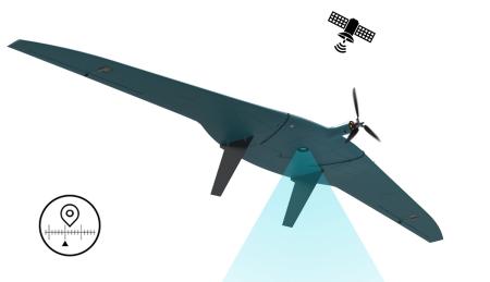
Geoscan 701 is a complex for aerial photography, which corresponds to the position "Unmanned aircraft system of aircraft type with internal combustion engine" Shooting area Flight duration Up to 10 hours
The survey area is 250 km2 (10 cm/pixels)
Aerial photography materials from Geoscan 701 are a set of images with exact moments of photographing and data from a geodetic—class GNSS receiver. The results of further data processing in the Agisoft Metashape program are orthophotoplans, digital terrain models, and digital terrain models in any coordinate system.
The ICE allows you to perform flight missions with a route length of up to 1000 km.
The possibility of simultaneous installation of multiple cameras.The on-board GNSS receiver of geodetic class and the precise determination of the moment of shooting make it possible to achieve high accuracy in determining the coordinates of the projection centers (CCPs) of images in PPK/RRR mode up to 1.5 cm. Automatic route construction for the selected area and the set shooting parameters in the Geoscan Planner software.
Fully automatic flight after launching from a catapult. After completing the flight, the UAV will parachute into a designated area. Conversion of GNSS data into a RINEX file with timestamps of the moments of photographing for calculating kinematics in any specialized software.
The ability to customize the payload.
Communication between the devices is carried out using the noise-resistant CAN interface.
Emergency operation mode in case of LDPE tube icing.
Automatic check of all systems before launch.
The presence of an autonomous flight recorder.
Autonomous flight with on-board position tracking via the Iridium system outside the range of radio communication with the NSO.
Extended service life of the internal combustion engine achieved through modernization.
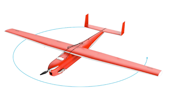
Hybrid landing system: parachute with balloon.
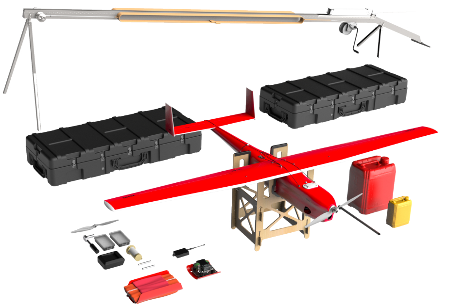
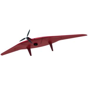
The Geoscan 701 complex includes an unmanned aircraft and a launcher, two transportation cases: for the catapult and for the side. The total weight is 160 kg.
Technical specifications
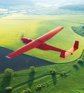
Max. flight duration: 10 hours.
Max. shooting area per flight: 70 km2 (3 cm/pixels) / 250 km2 (10 cm/pixels)
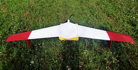
Wingspan 3.3 m
Flight speed: 80-120 km/h
Maximum take-off weight: 22 kg
Maximum payload weight: 3.5 kg
Maximum route length: 1,000 km
Maximum
flight altitude (above sea level): 4,500 m
Four—stroke gasoline engine: volume - 40 cm3, power — 3.75 hp
Take-off preparation time: 30 min.
Take-off/Landing: From the launcher / By parachute + balloon
Operating temperature range: -40° to 40°C
Case dimensions: 170×68×30 cm
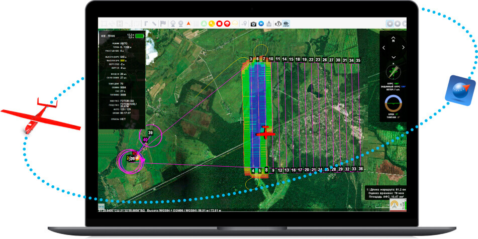
Geoscan Planner
Geoscan Planner software allows you to build flight tasks for shooting area and linear objects, use various flight modes (point-by-point, terrain-based, etc.), upload kml and kmz files, use various cartographic substrates, monitor flight and make changes to the flight task during its execution. After completing the mission, a RINEX file is created with timestamps of the moments of photographing.
Geoscan Planner Features:
3D environment for planning flight tasks based on terrain
Uploading and editing custom maps and substrates (wms, wmts, tiff, kmz, tls)
Automatic construction of a flight task based on kml files
Multiple coordinate systems
Remote manual control
Player Mode
Geoscan Planner software is included in the delivery package.
The survey area is 250 km2 (10 cm/pixels)
Aerial photography materials from Geoscan 701 are a set of images with exact moments of photographing and data from a geodetic—class GNSS receiver. The results of further data processing in the Agisoft Metashape program are orthophotoplans, digital terrain models, and digital terrain models in any coordinate system.
The ICE allows you to perform flight missions with a route length of up to 1000 km.
The possibility of simultaneous installation of multiple cameras.The on-board GNSS receiver of geodetic class and the precise determination of the moment of shooting make it possible to achieve high accuracy in determining the coordinates of the projection centers (CCPs) of images in PPK/RRR mode up to 1.5 cm. Automatic route construction for the selected area and the set shooting parameters in the Geoscan Planner software.
Fully automatic flight after launching from a catapult. After completing the flight, the UAV will parachute into a designated area. Conversion of GNSS data into a RINEX file with timestamps of the moments of photographing for calculating kinematics in any specialized software.
The ability to customize the payload.
Communication between the devices is carried out using the noise-resistant CAN interface.
Emergency operation mode in case of LDPE tube icing.
Automatic check of all systems before launch.
The presence of an autonomous flight recorder.
Autonomous flight with on-board position tracking via the Iridium system outside the range of radio communication with the NSO.
Extended service life of the internal combustion engine achieved through modernization.
Hybrid landing system: parachute with balloon.
The Geoscan 701 complex includes an unmanned aircraft and a launcher, two transportation cases: for the catapult and for the side. The total weight is 160 kg.
Technical specifications
Max. flight duration: 10 hours.
Max. shooting area per flight: 70 km2 (3 cm/pixels) / 250 km2 (10 cm/pixels)
Wingspan 3.3 m
Flight speed: 80-120 km/h
Maximum take-off weight: 22 kg
Maximum payload weight: 3.5 kg
Maximum route length: 1,000 km
Maximum
flight altitude (above sea level): 4,500 m
Four—stroke gasoline engine: volume - 40 cm3, power — 3.75 hp
Take-off preparation time: 30 min.
Take-off/Landing: From the launcher / By parachute + balloon
Operating temperature range: -40° to 40°C
Case dimensions: 170×68×30 cm
Geoscan Planner
Geoscan Planner software allows you to build flight tasks for shooting area and linear objects, use various flight modes (point-by-point, terrain-based, etc.), upload kml and kmz files, use various cartographic substrates, monitor flight and make changes to the flight task during its execution. After completing the mission, a RINEX file is created with timestamps of the moments of photographing.
Geoscan Planner Features:
3D environment for planning flight tasks based on terrain
Uploading and editing custom maps and substrates (wms, wmts, tiff, kmz, tls)
Automatic construction of a flight task based on kml files
Multiple coordinate systems
Remote manual control
Player Mode
Geoscan Planner software is included in the delivery package.
Fixed-wing UAVs
Wholesale prices
0 ₽
Email
Phone number
Connection will be made via internet - no charges apply. Microphone access required.
Leasing/Insurance
Adding to Favorites
Your comment: