Your city — Москва?
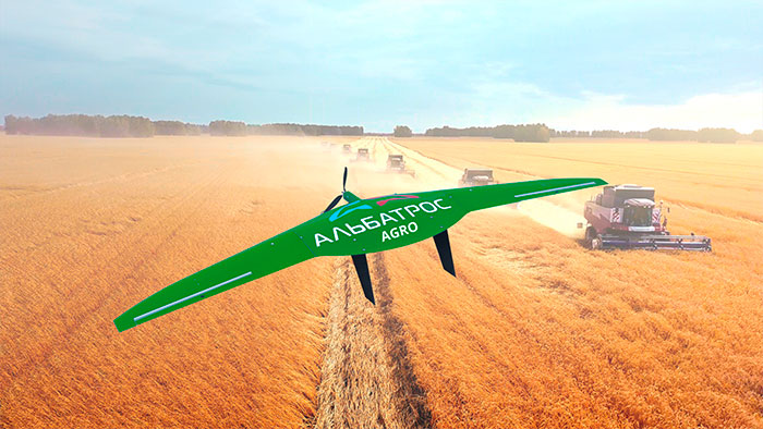
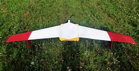
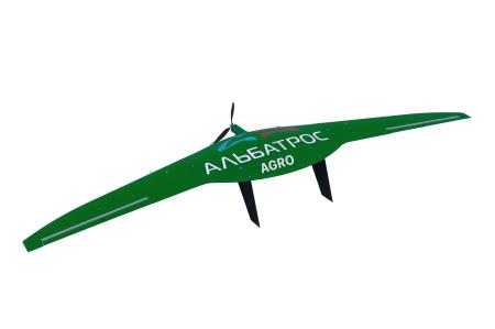
Fixed wing UAV ALBATROS M5 AGRO

Вологда
and more
60 городов
Offer valid for the following list of cities:
Вологда
Воронеж
Запорожье
Иваново
Иркутск
Калининград
Калуга
Кемерово
Кострома
Курган
Курск
Гатчина
Липецк
Магадан
Мурманск
Нижний Новгород
Великий Новгород
Новосибирск
Омск
Оренбург
Орёл
Пенза
Псков
Ростов-на-Дону
Рязань
Самара
Южно-Сахалинск
Екатеринбург
Смоленск
Тамбов
Тверь
Томск
Тула
Тюмень
Ульяновск
Херсон
Челябинск
Ярославль
Москва
Санкт-Петербург
Севастополь
Биробиджан
Нарьян-Мар
Ханты-Мансийск
Анадырь
Салехард
Волгоград
Владимир
Брянск
Белгород
Астрахань
Архангельск
Хабаровск
Ставрополь
Владивосток
Пермь
Красноярск
Сочи
Краснодар
Петропавловск-Камчатский
Чита
Category:
Special machinery manufacturer:
Model:
Condition:
New
Availability:
Not specified
#30012
Specifications
The M5 AGRO unmanned complex is designed for
agricultural enterprises. The M5 AGRO unmanned complex is a ready-made solution for agriculture. It allows you to receive and independently process information about your fields and the operations taking place on them. The kit includes: an Albatross M5 UAV, a camera, a ground control station, and additionally a multispectral camera can be included in the complex. The warranty is 1 year or 100 take-off/landing cycles.
Flight duration is up to 4.5 hours
The route length is 300 km.
The motor is Electric
It is possible to install a multispectral camera
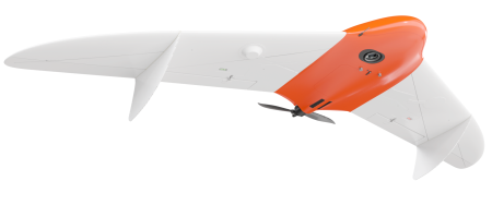
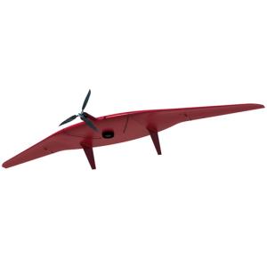
Aircraft type of vehicle
The scheme of the flying wing apparatus
Wingspan 3.3 m
Type of motor pulling, electric (brushless)
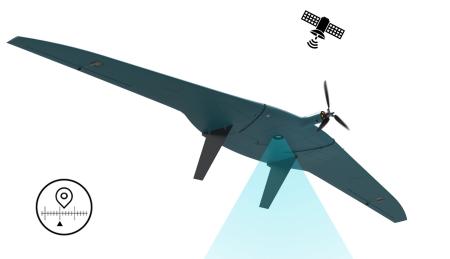
GPS/ Glonass positioning System
Li-Po / Li-Ion batteries (4 pcs.)
Maximum flight time 4.5 hours
The area of aerial photography per flight is up to 20 sq2
Cruising flight speed 72 km/h
Working height range 800-5000 m
The flight speed range is 65-120 km/h
The maximum flight altitude is 1000 m
The maximum route length is 300 km.
The maximum take-off weight is 15 kg
The maximum payload weight is 5 kg
There is an on-board recording of telemetry data
The method of take-off using a catapult (elastic /pneumatic)
The method of landing is parachute in semi-automatic mode
Take-off/landing site dimensions from 100x100 m
Wind resistance up to 18 m/s
Operating temperature range -30 °C ... +50 °C
Degree of protection IP56
The deployment time is 10 minutes
Transport dimensions 1200x800x150 mm
Universal payload mount (type 1)
Preventing damage during landing by detaching the wings
Emergency Search System Autonomous GPS Tracker/Radio Beacon
There is a parachute sling release system after landing
The hull life is up to 300 take-off/landing cycles
The range of operation in direct radio visibility is up to 90 km
There is a flight in the absence of communication
Appointment
Control of each field at all stages of the production process.
Improving the speed and accuracy of obtaining information from the fields.
Obtaining visual information on the quality of work performed in the field.
Accumulation of high-precision snapshots of fields for their automatic analysis.
Building electronic field maps.
Assessment of crop quality.
Inventory and audit of the land fund.
Building digital surface models.
Assessment of the efficiency of the NWR.
Detection of violations during agrotechnical operations.
Creation of maps of NDVI vegetation indexes (in the presence of a multispectral camera).
Equipment
The M5 AGRO unmanned complex includes all the necessary elements:
– Albatross M5 AGRO unmanned aircraft
– Payload for aerial photography
– Ground set of radio equipment and antennas
– License for the drone control program
– Battery pack and charger
– Elastic catapult with drill
– Shipping cases and cases
– Simplified ZIP kit
– Accompanying documentation
– Instruction on use for a crew of two operators
agricultural enterprises. The M5 AGRO unmanned complex is a ready-made solution for agriculture. It allows you to receive and independently process information about your fields and the operations taking place on them. The kit includes: an Albatross M5 UAV, a camera, a ground control station, and additionally a multispectral camera can be included in the complex. The warranty is 1 year or 100 take-off/landing cycles.
Flight duration is up to 4.5 hours
The route length is 300 km.
The motor is Electric
It is possible to install a multispectral camera
Aircraft type of vehicle
The scheme of the flying wing apparatus
Wingspan 3.3 m
Type of motor pulling, electric (brushless)
GPS/ Glonass positioning System
Li-Po / Li-Ion batteries (4 pcs.)
Maximum flight time 4.5 hours
The area of aerial photography per flight is up to 20 sq2
Cruising flight speed 72 km/h
Working height range 800-5000 m
The flight speed range is 65-120 km/h
The maximum flight altitude is 1000 m
The maximum route length is 300 km.
The maximum take-off weight is 15 kg
The maximum payload weight is 5 kg
There is an on-board recording of telemetry data
The method of take-off using a catapult (elastic /pneumatic)
The method of landing is parachute in semi-automatic mode
Take-off/landing site dimensions from 100x100 m
Wind resistance up to 18 m/s
Operating temperature range -30 °C ... +50 °C
Degree of protection IP56
The deployment time is 10 minutes
Transport dimensions 1200x800x150 mm
Universal payload mount (type 1)
Preventing damage during landing by detaching the wings
Emergency Search System Autonomous GPS Tracker/Radio Beacon
There is a parachute sling release system after landing
The hull life is up to 300 take-off/landing cycles
The range of operation in direct radio visibility is up to 90 km
There is a flight in the absence of communication
Appointment
Control of each field at all stages of the production process.
Improving the speed and accuracy of obtaining information from the fields.
Obtaining visual information on the quality of work performed in the field.
Accumulation of high-precision snapshots of fields for their automatic analysis.
Building electronic field maps.
Assessment of crop quality.
Inventory and audit of the land fund.
Building digital surface models.
Assessment of the efficiency of the NWR.
Detection of violations during agrotechnical operations.
Creation of maps of NDVI vegetation indexes (in the presence of a multispectral camera).
Equipment
The M5 AGRO unmanned complex includes all the necessary elements:
– Albatross M5 AGRO unmanned aircraft
– Payload for aerial photography
– Ground set of radio equipment and antennas
– License for the drone control program
– Battery pack and charger
– Elastic catapult with drill
– Shipping cases and cases
– Simplified ZIP kit
– Accompanying documentation
– Instruction on use for a crew of two operators
Fixed-wing UAVs
Wholesale prices
0 ₽
Email
Phone number
Connection will be made via internet - no charges apply. Microphone access required.
Leasing/Insurance
Adding to Favorites
Your comment: